
The Cocora Valley Hike In Colombia – 2024 Guide

Nestled in the heart of Colombia’s coffee region lies the beautiful Cocora Valley, a place of breathtaking beauty and natural wonder. This valley is surrounded by towering mountains, lush green forests, and rolling hills that seem to go on forever. It’s a place where you can escape from the hustle and bustle of everyday life and immerse yourself in the tranquillity and serenity of nature. And what better way to experience all of this than by embarking on the Cocora Valley hike.
You’ll see varying reports of the hike altitude online but my Strava data shows starting at 2207 m and ending at 2093 m which makes 696 m of elevation gain over about 13km of walking. I’m not used to walking at such high altitudes so I had a quick check and there is 2% less oxygen at the top compared to sea level – I didn’t really notice the effects though.
If it’s gonna rain, it tends to come after lunchtime so we started the day pretty early. We took a Jeep from the main square in Salento which costs around X per person. Be prepared to hang off the back if it’s busy as they really pack people in! It’s not too bad though – there’s a little platform to put your feet on.
So it was me and 6 friends on the hike. We started the Cocora Valley walk after the 30-minute jeep ride along winding roads from Salento. It had rained heavily before we arrived, so three of us rented wellies to avoid ruining our trainers with mud. The others took their chances with just their trainers. It was a cloudy day with a temperature of around 19 degrees, and we knew that rain was predicted for later in the day. Our goal was to keep a good pace and avoid getting caught in the rain, so we decided to take the anti-clockwise route to reach the Cocora Valley views at the end of the hike.

A little note on this. The long hiking route is about 13km and goes anti-clockwise. Take this route if you want to have a hiking experience and really put in some effort. The easier “strolling” route is clockwise. Taking this path, you just walk up to the palm trees and can then turn back around, or continue to the highest point where there is a lookout. At the end of the longer hike which shares the path with the clockwise route, you see people in casual clothes ascending to see the trees and wonder for a second where they came from.
Anyway, we began the hike by walking over a small wooden suspension bridge, the kind you might see in movies. It was a gentle incline along a small, muddy path lined with fields on both sides, where cows were grazing. The path quickly became very muddy, and those with trainers soon found themselves ankle-deep in mud. Shortly after starting there’s a payment hut. You have to pay 6k pesos to enter the national park. There’s quite high inflation in Colombia, so this will vary over time.

After passing this section, we entered the forest, and the incline increased, making the hike a little harder. Our first stop was a waterfall, which we had to take tiny detour from the trail to see. After taking some photos, we returned to the trail and continued on our way. The trail wound its way through the forest, with a moderate incline, crossing rivers and exciting wooden suspension bridges along the way.

As we reached a split in the trail, we had a decision to make. We could continue left to the highest point, or take a 1.1km detour up to a lookout point where we could see hummingbirds and take a break. We chose to take the detour and were glad we did. We reached the hummingbird area after about half an hour, and paid the 15,000 peso fee to enter. It was a great place to rest and sit for a while, surrounded by the beauty of nature and the sound of hummingbirds flitting about. They even had public toilets available and as part of the fee, you are given coffee or hot chocolate.

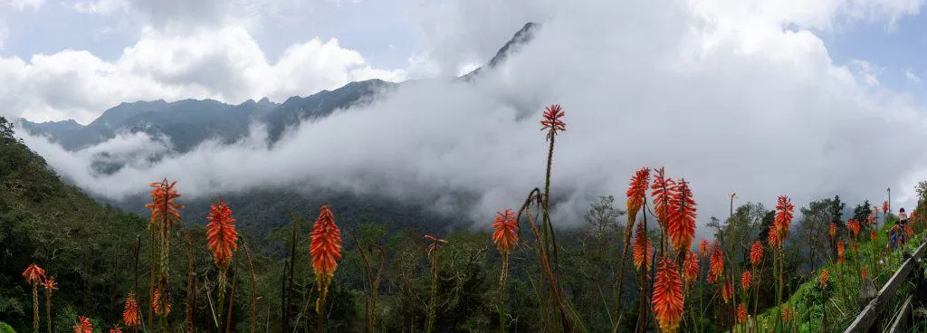
Once we were rested and refreshed, we continued back down to the trail split and took a right turn up to the summit. This part of the hike was much steeper, and our heart rates were definitely pushed. But the reward was worth it, as we reached the highest point of the trail with a stunning view of the mountains. I reached the top first and took some photos, but by the time my friends arrived just a few minutes later, the view was completely gone. The clouds had set in, which also meant that the rain was coming.

From this point, we started to descend into the valley towards the palm trees. As we reached the palm trees, the rain began to fall. We took some quick photos together and continued on to the end of the hike. The valley views were amazing, with horses grazing along the way. The rain picked up to a steady, heavy downpour, but we were lucky to have ponchos and waterproof coats to keep us mostly dry.

There’s another payment point on this section of the walk. It’s to make sure people coming the other way are paying too, but you’ll pay either way you pass it – so you’re essentially paying to exit the national park too if you do the anti-clockwise hike.
We reached the end of the hike about 3 hours and 20 minutes after starting. In all, it was a really nice walk. We took lots of photos and felt like we had earnt a nice lunch afterwards.

Note: There may be a wait to grab a Jeep back to Salento, so don’t expect to go straight there. You can also eat at the start point as there are a few restaurants and infrastructure for tourists.
Trail Costs
6k to enter route trail
10k to exit route trail
15k to enter the optional hummingbird area – you get an included hot drink
Tips for the Cocora Valley hike
The jeeps from Salento to Cocora valley leave between 6:30am and 4:00pm and cost between 5000-7000 COP each way.
The pickup points for the Jeeps is the Plaza de Bolívar in Salento.
You will need some Colombian pesos for the jeep, the hummingbird detour and the trail fees.
Bring hiking shoes to cross streams and a waterproof jacket just in case the weather turns.
You’ll gain about 1,000 meters in elevation from Salento with the highest point being 2,860 meters above sea level.
Some cafes and hostels in Salento provide a packed lunch for the hike. You can also get lunch and refill water at Finca La Montaña. But bring extra snacks.
